Salt rocks and mud wallows in The Isle: Evrima
Gateway has 23 salt rocks and 21 mud wallows. They're all on one numbered map below, with the Lat and Long you see in the game's Tab menu.
What does a salt lick do in The Isle?
A salt lick removes sickness, such as vomit sickness and the bacterial infection from a Ceratosaurus bite. Walk up to a salt rock and hold E to lick it.
Licking also drains one nutrient: the active nutrient you choose in the status screen, added in patch 0.17.54. Carnivores lick salt too; the developers have fixed the Herrerasaurus salt-lick animation.
What does a mud wallow do?
Wallowing in mud gives you bleed resistance, so you tolerate a bleed better. It never stops a bleed. While you are covered, the mud also hides your scent and your blood trail, which makes you harder to track. Rest as well while the bleed wears off, and remember that moving fast drains blood quicker.
Swimming and rain wash the mud off, and the cover goes with it. The wallow effect stays when you take damage. Heavy animals sink in deep mud, which slows them and costs stamina.
Where are the salt rocks in The Isle: Evrima?
Atlas Maps' map data has 23 salt rocks and 21 mud wallows on Gateway. Salt rocks are spread over the whole island; the Delta has the most (4), followed by North Plains, Eastern Jungle and Redwood. On the map, salt rocks are white and numbered S1 to S23; mud wallows are orange and numbered M1 to M21.
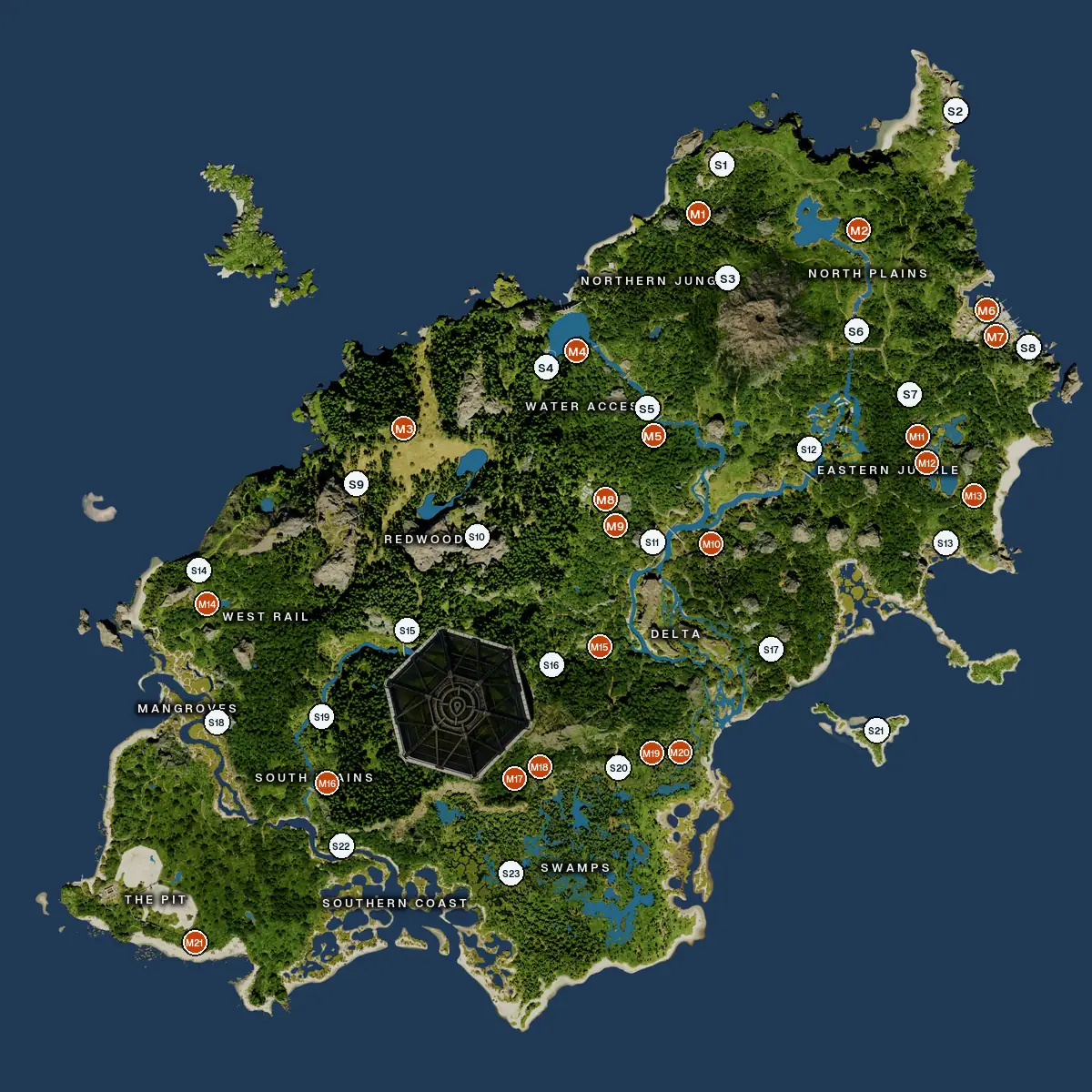
| # | Area | Nearest named place | Lat | Long |
|---|---|---|---|---|
| S1 | Northern JungleNorth Lake | North Lake | −438,000 | 231,000 |
| S2 | North PlainsNE Cape | NE Cape | −492,000 | 470,000 |
| S3 | Northern JungleVolcano Chamber | Volcano Chamber | −321,000 | 237,000 |
| S4 | Water AccessDam Lake | Dam Lake | −231,000 | 51,000 |
| S5 | Water AccessCascades Bridge | Cascades Bridge | −180,000 | 156,000 |
| S6 | North PlainsNorth Bridge | North Bridge | −267,000 | 367,000 |
| S7 | Eastern JungleEastern Jungle | Eastern Jungle | −202,000 | 421,000 |
| S8 | North PlainsNorth Tunnel Entrance | North Tunnel Entrance | −250,000 | 542,000 |
| S9 | RedwoodRedwood Lake (South) | Redwood Lake (South) | −112,000 | −142,000 |
| S10 | RedwoodRedwood Lake (South) | Redwood Lake (South) | −58,000 | −20,000 |
| S11 | DeltaDelta Bridge | Delta Bridge | −52,000 | 159,000 |
| S12 | Eastern JungleUnderpass Bridge | Underpass Bridge | −146,000 | 318,000 |
| S13 | Eastern JungleTide Pool | Tide Pool | −50,000 | 457,000 |
| S14 | West RailWest Pond | West Pond | −24,000 | −303,000 |
| S15 | RedwoodShade Puddle | Shade Puddle | 38,000 | −92,000 |
| S16 | DeltaJungle Pond | Jungle Pond | 74,000 | 55,000 |
| S17 | DeltaCoastal Pond | Coastal Pond | 58,000 | 278,000 |
| S18 | MangrovesMangroves | Mangroves | 131,000 | −286,000 |
| S19 | South PlainsGorge River | Gorge River | 126,000 | −179,000 |
| S20 | SwampsSouth Swamp Tunnel | South Swamp Tunnel | 179,000 | 122,000 |
| S21 | DeltaSandbank Bay | Sandbank Bay | 142,000 | 385,000 |
| S22 | South PlainsSouth Plains | South Plains | 258,000 | −160,000 |
| S23 | SwampsSwamp West | Swamp West | 286,000 | 13,000 |
Where are the mud wallows?
The 21 mud wallows are most common around Water Access, Delta, North Plains and Eastern Jungle. Some come in pairs a few steps apart, like M11 and M12 in the Eastern Jungle.
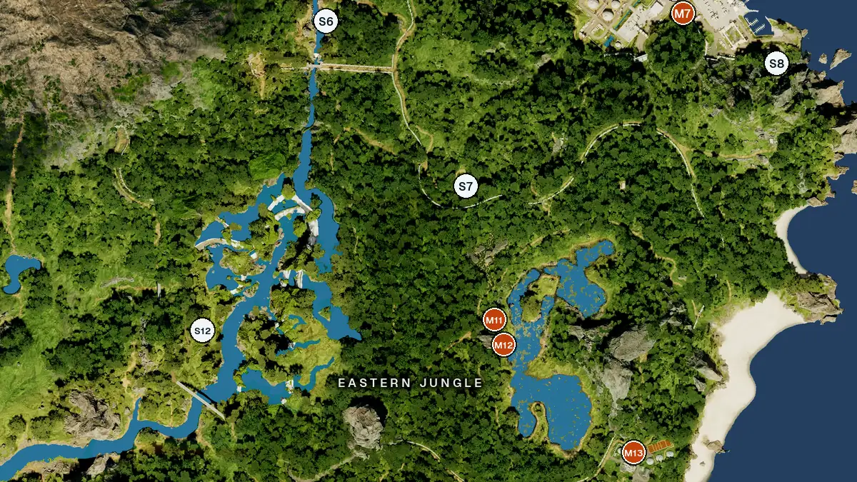
| # | Area | Nearest named place | Lat | Long |
|---|---|---|---|---|
| M1 | Northern JungleNorthern Jungle | Northern Jungle | −388,000 | 207,000 |
| M2 | North PlainsNorth Lake | North Lake | −370,000 | 370,000 |
| M3 | RedwoodRedwood Lake (North) | Redwood Lake (North) | −168,000 | −94,000 |
| M4 | Water AccessDam Lake | Dam Lake | −247,000 | 82,000 |
| M5 | Water AccessCascades Bridge | Cascades Bridge | −170,000 | 158,000 |
| M6 | North PlainsSmall Stream | Small Stream | −276,000 | 504,000 |
| M7 | North PlainsSmall Stream | Small Stream | −273,000 | 505,000 |
| M8 | Water AccessDelta Bridge | Delta Bridge | −87,000 | 114,000 |
| M9 | Water AccessDelta Bridge | Delta Bridge | −77,000 | 118,000 |
| M10 | DeltaDelta River | Delta River | −50,000 | 218,000 |
| M11 | Eastern JungleEast Lake | East Lake | −148,000 | 433,000 |
| M12 | Eastern JungleEast Lake | East Lake | −143,000 | 434,000 |
| M13 | Eastern JungleEast Lake | East Lake | −98,000 | 486,000 |
| M14 | West RailWest Pond | West Pond | 10,000 | −295,000 |
| M15 | DeltaJungle Pond | Jungle Pond | 55,000 | 104,000 |
| M16 | South PlainsSouth Plains | South Plains | 194,000 | −174,000 |
| M17 | SwampsSilent Lake | Silent Lake | 188,000 | 21,000 |
| M18 | SwampsSouth Swamp Tunnel | South Swamp Tunnel | 180,000 | 39,000 |
| M19 | DeltaSouth Swamp Tunnel | South Swamp Tunnel | 164,000 | 165,000 |
| M20 | DeltaSouth Swamp Tunnel | South Swamp Tunnel | 164,000 | 177,000 |
| M21 | The PitPit Puddle II | Pit Puddle II | 356,000 | −309,000 |
Which areas have both salt and mud?
9 areas have at least one of each: Delta, Water Access, North Plains, Eastern Jungle, Redwood, Swamps, Northern Jungle, South Plains and West Rail. The table counts both per area, using the nearest area name on the map.
| Area | Salt | Mud |
|---|---|---|
| Delta | 4 | 4 |
| Eastern Jungle | 3 | 3 |
| North Plains | 3 | 3 |
| Water Access | 2 | 4 |
| Redwood | 3 | 1 |
| Swamps | 2 | 2 |
| Northern Jungle | 2 | 1 |
| South Plains | 2 | 1 |
| West Rail | 1 | 1 |
| Mangroves | 1 | 0 |
| The Pit | 0 | 1 |
How do you find them from your coordinates?
Open the Tab menu in game to see your own Lat and Long, then compare them with the table. The numbers are rounded to the nearest 1,000, which on Gateway is a short walk.
How do you see salt and mud on the map while you play?
Press M in game and the Gateway map opens over The Isle with you on it. The salt and mud layers are on from the start. Every spot has a dot and a label, "Salt" or "Mud wallow", so you can tell them apart without a legend. Turn either layer off under Layers in the map's settings (the gear button).
- TargetRight-click a salt rock or mud wallow to make it your target. The distance follows you on the map and the compass.
- PartyAdd it as a party spot so your whole party sees it.
Salt and mud at a glance
- Salt23 salt rocks on Gateway, most around the Delta.
- Mud21 mud wallows, most around Water Access and Delta. Mud gives bleed resistance and hides your scent and blood trail.
- Both9 areas have at least one of each.
Common questions
Does salt cure vomit sickness?
Yes. Vomit sickness starts every time you vomit, lasts 5 minutes and stacks, and it lowers your max stamina, hunger and thirst. Licking a salt rock removes it faster than waiting.
Does salt cure a Ceratosaurus infection?
Yes. Since patch 0.20.109, licking salt removes the bacteria.
Does salt cure muscle spasms?
No. Salt removes sickness, but nothing cures muscle spasms; they wear off after about 15 to 20 minutes.
Does mud stop bleeding?
No. Mud never stops bleeding. It gives you bleed resistance, so you tolerate the bleed better; rest while the bleed wears off.
Does mud hide your scent in The Isle?
Yes. While you are covered in mud it hides your scent and your blood trail. Swimming and rain wash it off.
Can carnivores use salt and mud?
Yes. Both herbivores and carnivores, such as Ceratosaurus and Herrerasaurus, have salt-lick and wallow animations in the game.
Read next
- Vomit sicknessWhat causes it and how salt removes it.
- How to stop bleedingMud, rest and what makes it worse.
- Water sources29 named lakes, ponds and rivers.
- Gastrolith locations245 spots on one map.
- Sanctuary locationsAll 7 sanctuaries, numbered.
- Updraft locations13 updrafts and the airflow lines.
- The live mapYour position, trail, targets and walls.
Atlas Maps for The Isle: Evrima
Free for the first 2,000 players, or until 5 December 2026, whichever comes first.$5, VAT included. Windows 10 and 11.
Download Atlas Maps