Gateway map locations and names in The Isle: Evrima
Atlas Maps' map of Gateway has 64 named places: 12 areas, 29 lakes, ponds, rivers and other water, 16 landmarks (bridges, tunnels, beaches and more), 4 seas and bays and 3 land features. Here they all are on one numbered map with the Lat and Long from the game's Tab menu. The names are the map's labels; only some of them appear in the developers' patch notes.
What are the main areas of the Gateway map?
Gateway is split into 12 area names on the map: North Plains, Northern Jungle, Water Access, Eastern Jungle, Redwood, West Rail, Delta, Mangroves, South Plains, Swamps, The Pit and Southern Coast. They are listed north to south below, with the Lat and Long of each label.
| Area | Lat | Long |
|---|---|---|
| North Plains | −326,000 | 379,000 |
| Northern Jungle | −319,000 | 166,000 |
| Water Access | −191,000 | 92,000 |
| Eastern Jungle | −125,000 | 399,000 |
| Redwood | −55,000 | −75,000 |
| West Rail | 23,000 | −236,000 |
| Delta | 42,000 | 181,000 |
| Mangroves | 117,000 | −315,000 |
| South Plains | 188,000 | −187,000 |
| Swamps | 281,000 | 78,000 |
| The Pit | 312,000 | −349,000 |
| Southern Coast | 317,000 | −106,000 |
Where is every named place on Gateway?
The map numbers all 64 names from north to south, and the table gives the Lat and Long of each one. The colour of a number shows the kind of place: white for areas, light blue for water, darker blue for seas and bays, green for land features and pale blue for landmarks.
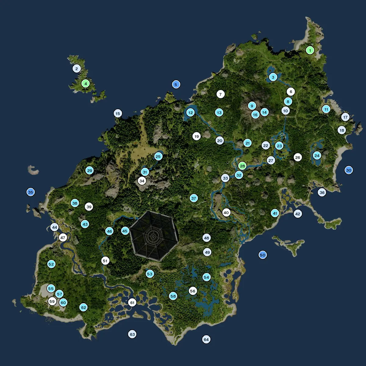
| # | Name | Kind and area | Lat | Long |
|---|---|---|---|---|
| 1 | NE CapeLand, North Plains | Land, North Plains | −452,000 | 438,000 |
| 2 | Fisher RowLandmark, Redwood | Landmark, Redwood | −398,000 | −271,000 |
| 3 | North LakeWater, North Plains | Water, North Plains | −371,000 | 325,000 |
| 4 | Rock IslandLand, Redwood | Land, Redwood | −352,000 | −243,000 |
| 5 | North BaySea and bays, Northern Jungle | Sea and bays, Northern Jungle | −349,000 | 31,000 |
| 6 | North PlainsArea | Area | −326,000 | 379,000 |
| 7 | Northern JungleArea | Area | −319,000 | 166,000 |
| 8 | Plains RiverWater, North Plains | Water, North Plains | −290,000 | 369,000 |
| 9 | Volcano ChamberWater, Northern Jungle | Water, Northern Jungle | −282,000 | 262,000 |
| 10 | North BridgeLandmark, North Plains | Landmark, North Plains | −274,000 | 365,000 |
| 11 | Small StreamWater, North Plains | Water, North Plains | −272,000 | 487,000 |
| 12 | Dam LakeWater, Water Access | Water, Water Access | −263,000 | 74,000 |
| 13 | Verdant PondWater, Northern Jungle | Water, Northern Jungle | −263,000 | 161,000 |
| 14 | VC IIIWater, North Plains | Water, North Plains | −262,000 | 292,000 |
| 15 | RidgesLandmark, Redwood | Landmark, Redwood | −261,000 | −146,000 |
| 16 | VC IIWater, North Plains | Water, North Plains | −259,000 | 277,000 |
| 17 | North Tunnel EntranceLandmark, North Plains | Landmark, North Plains | −248,000 | 545,000 |
| 18 | South Tunnel EntranceLandmark, Eastern Jungle | Landmark, Eastern Jungle | −208,000 | 533,000 |
| 19 | Water AccessArea | Area | −191,000 | 92,000 |
| 20 | Cascades BridgeLandmark, Water Access | Landmark, Water Access | −177,000 | 163,000 |
| 21 | Forks PondWater, Water Access | Water, Water Access | −170,000 | 247,000 |
| 22 | Underpass BridgeLandmark, Eastern Jungle | Landmark, Eastern Jungle | −162,000 | 302,000 |
| 23 | Hollow FallsWater, Eastern Jungle | Water, Eastern Jungle | −161,000 | 343,000 |
| 24 | East LakeWater, Eastern Jungle | Water, Eastern Jungle | −131,000 | 457,000 |
| 25 | Redwood Lake (North)Water, Redwood | Water, Redwood | −130,000 | −24,000 |
| 26 | Eastern JungleArea | Area | −125,000 | 399,000 |
| 27 | Hollow Falls BridgeLandmark, Eastern Jungle | Landmark, Eastern Jungle | −116,000 | 317,000 |
| 28 | Forks PlainsLand, Delta | Land, Delta | −100,000 | 231,000 |
| 29 | Landslid LakeWater, West Rail | Water, West Rail | −88,000 | −233,000 |
| 30 | East CoastSea and bays, Eastern Jungle | Sea and bays, Eastern Jungle | −86,000 | 554,000 |
| 31 | Redwood Lake (South)Water, Redwood | Water, Redwood | −81,000 | −65,000 |
| 32 | Delta RiverWater, Delta | Water, Delta | −72,000 | 220,000 |
| 33 | Delta BridgeLandmark, Delta | Landmark, Delta | −63,000 | 179,000 |
| 34 | RedwoodArea | Area | −55,000 | −75,000 |
| 35 | West CoastSea and bays, Mangroves | Sea and bays, Mangroves | −22,000 | −412,000 |
| 36 | Tide PoolLandmark, Eastern Jungle | Landmark, Eastern Jungle | −18,000 | 472,000 |
| 37 | Jungle PondWater, Delta | Water, Delta | −2,000 | 82,000 |
| 38 | West PondWater, West Rail | Water, West Rail | 12,000 | −279,000 |
| 39 | West RailArea | Area | 23,000 | −236,000 |
| 40 | DeltaArea | Area | 42,000 | 181,000 |
| 41 | Coastal PondWater, Delta | Water, Delta | 45,000 | 329,000 |
| 42 | Sandbank BayLandmark, Eastern Jungle | Landmark, Eastern Jungle | 47,000 | 398,000 |
| 43 | Pygmy PuddleWater, West Rail | Water, West Rail | 76,000 | −248,000 |
| 44 | Turtle BayLandmark, Mangroves | Landmark, Mangroves | 85,000 | −341,000 |
| 45 | Shade PuddleWater, South Plains | Water, South Plains | 97,000 | −127,000 |
| 46 | Gorge RiverWater, South Plains | Water, South Plains | 98,000 | −174,000 |
| 47 | MangrovesArea | Area | 117,000 | −315,000 |
| 48 | North Swamp TunnelLandmark, Delta | Landmark, Delta | 120,000 | 121,000 |
| 49 | South Swamp TunnelLandmark, Swamps | Landmark, Swamps | 163,000 | 123,000 |
| 50 | Delta BaySea and bays, Delta | Sea and bays, Delta | 172,000 | 291,000 |
| 51 | South PlainsArea | Area | 188,000 | −187,000 |
| 52 | South PuddleWater, Mangroves | Water, Mangroves | 198,000 | −351,000 |
| 53 | Silent LakeWater, Southern Coast | Water, Southern Coast | 229,000 | −52,000 |
| 54 | Swamp EastWater, Swamps | Water, Swamps | 240,000 | 120,000 |
| 55 | Pit PuddleWater, The Pit | Water, The Pit | 273,000 | −352,000 |
| 56 | SwampsArea | Area | 281,000 | 78,000 |
| 57 | Pit PondWater, The Pit | Water, The Pit | 293,000 | −325,000 |
| 58 | Swamp WestWater, Swamps | Water, Swamps | 297,000 | 18,000 |
| 59 | The PitArea | Area | 312,000 | −349,000 |
| 60 | Pit Puddle IIWater, The Pit | Water, The Pit | 312,000 | −317,000 |
| 61 | Southern CoastArea | Area | 317,000 | −106,000 |
| 62 | Rock PondWater, The Pit | Water, The Pit | 330,000 | −254,000 |
| 63 | Southern Beach (West side)Landmark, Southern Coast | Landmark, Southern Coast | 413,000 | −107,000 |
| 64 | Southern Beach (East side)Landmark, Swamps | Landmark, Swamps | 429,000 | 118,000 |
Are these the official Gateway location names?
Not all of them. The names on this page are the labels on Atlas Maps' map. The developers use their own names in patch notes and DevBlogs, and only some match a label exactly.
- Same nameSouth Plains, Northern Jungle and Mangroves are both a map label and a name in the patch notes (patches 0.20.109, 0.13.42.18 and 0.21.720).
- CloseThe patch notes say Swamp, Redwoods, Jungle and West Rail Access; the map labels say Swamps, Redwood, Eastern Jungle and West Rail.
- NotesEast Plains, Highlands, West Plateau, Northwest Outpost, West Grasslands, Docks, Dome, Labs, DTA and Hatchery appear in patch notes or DevBlogs but are not labels on the map.
- Map onlyDelta and most lake, bridge and tunnel names are map labels. They don't appear as place names in the patch notes.
Use the patch-note names when you read the developers' notes, and the map labels with the coordinates on this page.
How do you find a named place from your coordinates?
Open the Tab menu to see your own Lat and Long, then find the row in the table with the closest numbers. Lat goes up to the south and Long to the east, and 1,000 is 10 metres. How to read the coordinates.
With Atlas Maps, press M and the map opens over the game with every name on it and you on it. The area names and the smaller water and place names are drawn on the map, so you can see which one you're closest to.
Gateway locations at a glance
- Count64 named places in Atlas Maps' map data.
- Kinds12 areas, 29 water, 16 landmarks, 4 seas and bays, 3 land features.
- NamesMap labels. South Plains, Northern Jungle and Mangroves also appear in the patch notes.
- FindCompare your Tab menu Lat and Long with the table, or press M with Atlas Maps.
Common questions
How many named places does the Gateway map have?
Atlas Maps' map data has 64 named places on Gateway, including 12 areas and 29 lakes, ponds, rivers and other water.
Is Delta an official name in The Isle?
Delta is a label on the map, but it does not appear as a place name in the developers' patch notes.
What are the official location names on Gateway?
Patch notes and DevBlogs name South Plains, East Plains, Highlands, West Rail Access, West Plateau, Northwest Outpost, West Grasslands, Docks, Swamp, Jungle, Northern Jungle, Redwoods, Mangroves, Dome, Labs, DTA and Hatchery.
Read next
Atlas Maps for The Isle: Evrima
Free for the first 2,000 players, or until 5 December 2026, whichever comes first.$5, VAT included. Windows 10 and 11.
Download Atlas Maps